Erfurt: 200 years of urban development in the mirror of topographic maps
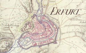
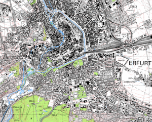
This essay was published in 2005 in the series "Landschaftsarchitektur, quo Vadis?". The ground plans of selected historical topographical maps (1798, 1853, 1873, 1936, 1998) were used to describe the development of the city of Erfurt from the administrative and garrison town of Kurmainz through the expanding industrial city of the Wilhelmine time to becoming Thuringia's capital, now known as one of central Germany's most lively and significant cities.
The remarkable functional changes accompanied by the simultaneous enormous increase in population, stimulated by stages of rapid industrialization and by the increase in traffic and transportation are all reflected in the city plan. Starting from the compact medieval core the city expanded as late as the 1870s after the removal of the fortified walls. During the following timespan of the “Gründerzeit” Wilhelminian style multi-family tenement and town-houses were constructed in the pattern of the classic checkered city road network in a belt around the old town core.
In only 60 years, the population of Erfurt tripled, from 40 000 (1871) to about 140 000 in the early 30s. In the southwestern part of Erfurt, bourgeois residential areas grew up, which are still among the most desirable addresses in Erfurt. These city villas and comfortable multi-family houses sit on an attractive location at the foot of the Steigerwald hill.
In the first third of the 20th century, new ideas from progressive architects and planners were also reflected in urban development. As a reaction to the housing shortage at that time, streets in the "Hanseviertel" were built since the late 1920s with multi-stored and multi-family houses in the style of "Neue Sachlichkeit", whose role models could be found in the North German Hanseatic cities.
Even the well-known concept of "Garden City Movement" has left its traces in Erfurt. Furthermore, extensive park and green areas characterize the city. The post-war period is documented by the presence of prefabricated housing units which were typical to all the major cities of the former GDR times. The post-revolutionary era left its mark by individual housing construction and the growing commercial centers on the edge of town.
from: H.-H. Meyer (2005): Erfurt. 200 Jahre Stadtentwicklung im Spiegel Topographischer Karten.- In: Landschaftsarchitektur quo vadis. Bewahren, entwerfen und pflegen. H.1, S. 60-73 (Festschrift f. Prof. J. Zilling). Erfurt.